Day 1 · no walking
Arrive in Newcastle
An easy beginning
Walking: None, travel day
TonightNewcastle, in a hotel or B&B we've booked, with breakfast in the morning.


See what your Hadrian’s Wall walk actually feels like, day by day, before you walk it: the city, the farmland, the crags and the Solway shore.
One Wall, your pace
Every itinerary walks the same path. What changes is where you sleep, how far you go each day, and how much time you have for the forts. Pick one and watch how it divides the Wall.
Full crossings, coast to coast
Short breaks, one section
Full coast to coast · 8 walking days
Difficulty, honestly: The gentlest way anyone can walk this trail while still walking all of it. Best for: Walkers who want the gentlest full crossing, no long days at all.
The Unhurried Wall
Day 1 of 8 · mile 0 of 84
Day 1 · no walking
An easy beginning
Walking: None, travel day
TonightNewcastle, in a hotel or B&B we've booked, with breakfast in the morning.
Day 2 · walking day 1 of 8

Today feels like
A flat, friendly first day
The trail starts at Segedunum, where the wall once ran right down to the Tyne. The viewing tower is worth twenty minutes before the first step.
Surfaced riverside paths through Newcastle, under the bridges and past the quayside cafés. Navigation is as simple as following the river.
The path climbs gently away from the river into farmland. No visible wall yet: this stretch is about settling your legs and your pace.
On the way
TonightHeddon-on-the-Wall, in a hotel or B&B we've booked, with breakfast in the morning.
Your main bag is already there when you arrive.
Tomorrow: Heddon-on-the-Wall to Corbridge — gentle, with a Roman town at the end.
Day 3 · walking day 2 of 8
Today feels like
Gentle, with a Roman town at the end
Quiet farmland beside the Military Road, which sits on the wall's foundations for miles. The ditch and the Vallum, the great earthworks either side of the wall, become your companions.
The Robin Hood Inn near East Wallhouses is the natural lunch stop, and the sense of leaving the lowlands behind grows mile by mile.
Corbridge, a proper market town just off the trail, with the Roman supply town of Coria nearby.
TonightCorbridge, in a hotel or B&B we've booked, with breakfast in the morning.
Your main bag is already there when you arrive.
Tomorrow: Corbridge to Chollerford — a short, easy morning.
This is The Unhurried Wall: 8 walking days, from £1,019 per person.
See prices & full itineraryDay 4 · walking day 3 of 8

Today feels like
A short, easy morning
Back to the wall line and a short day north-west to the North Tyne valley, arriving at Chollerford with the whole afternoon free.
On the way
TonightChollerford, in a hotel or B&B we've booked, with breakfast in the morning.
Your main bag is already there when you arrive.
Tomorrow: Chollerford to Once Brewed — the big day, met on fresh legs.
Day 5 · walking day 4 of 8
Today feels like
The big day, met on fresh legs
Out of the North Tyne valley the path climbs steadily onto open moorland.
At Sewingshields the Whin Sill begins: a rollercoaster of short, sharp climbs and descents along the crags, the wall riding the edge beside you, views that stretch to Scotland.
Housesteads, the most complete Roman fort in Britain, sits right on the path. Stand at the north gate and you look at the ground Roman sentries watched.
Sycamore Gap. The tree was felled by vandals in 2023, but the gap itself, wall plunging in and climbing out, remains one of the finest sights on the trail.
The Sill visitor centre and the Twice Brewed Inn sit just below the crags; Vindolanda is a steep mile or so south.
On the way
TonightOnce Brewed, in a hotel or B&B we've booked, with breakfast in the morning.
Your main bag is already there when you arrive.
Tomorrow: Once Brewed to Gilsland — short, high and glorious.
That was the hardest day on this itinerary. Want it shorter? Try a slower pace above.
See prices & full itineraryDay 6 · walking day 5 of 8

Today feels like
Short, high and glorious
Winshield Crags, at 345 m the highest point of the whole trail.
Cawfields' knife-edge wall above the quarry lake, with a seasonal café at the car park.
Great Chesters, an unexcavated fort beside the path, free and usually empty.
Thirlwall Castle, built from scavenged Roman stone, sits below the western end of the crags.
Gilsland straddles the Northumberland–Cumbria border. Poltross Burn milecastle, behind the old station, is one of the best preserved on the wall and most walkers march straight past it.
On the way
TonightGilsland, in a hotel or B&B we've booked, with breakfast in the morning.
Your main bag is already there when you arrive.
Tomorrow: Gilsland to Brampton, via Birdoswald — a soft day with a great fort.
Day 7 · walking day 6 of 8

Today feels like
A soft day with a great fort
The geology relents: long, low miles through Cumbrian pasture and quiet lanes, the wall a buried presence, carted off long ago to build Lanercost Priory and half of Carlisle.
On the way
TonightBrampton, in a hotel or B&B we've booked, with breakfast in the morning.
Your main bag is already there when you arrive.
Tomorrow: Brampton to Carlisle — easy miles to a proper city.
Day 8 · walking day 7 of 8
Today feels like
Easy miles to a proper city
The path joins the River Eden for the final approach, arriving in Carlisle through Rickerby Park.
TonightCarlisle, in a hotel or B&B we've booked, with breakfast in the morning.
Your main bag is already there when you arrive.
Tomorrow: Carlisle to Bowness-on-Solway — a long day, but pan-flat and full of sky.
Day 9 · walking day 8 of 8
Today feels like
A long day, but pan-flat and full of sky
Along the Eden and out onto the Solway Plain: flat, wide-skied, and utterly different from everything before it.
Burgh-by-Sands, where Edward I died on the marshes waiting to invade Scotland. The path runs on along the estuary road across open saltmarsh.
On the way
TonightBowness-on-Solway, in a hotel or B&B we've booked, with breakfast in the morning.
Your main bag is already there when you arrive.
Day 10 · no walking
Earned contentment
Walking: None, travel day
Trail mile 0 of 84
Day 1 of 8
Wallsend → Heddon-on-the-Wall
The official trail line, north–south stretched for clarity. Diamonds mark the Roman forts on the path. Trail line © OpenStreetMap contributors.
The lie of the land
Landscape
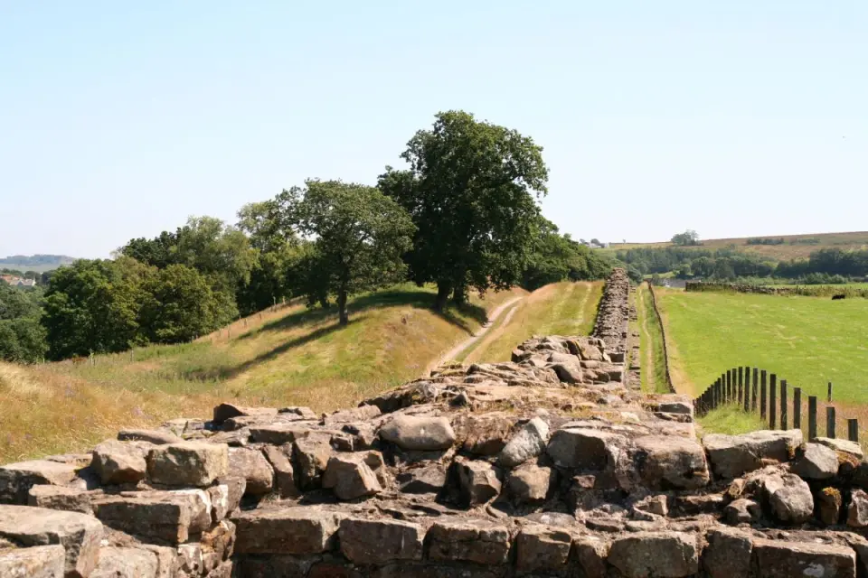
Northumberland farmland
Long green miles beside the Military Road, the ditch and the Vallum for company.
Which pace is right for me?
We’ll match your answers against the real days of every itinerary: how many there are, and how long the longest one is. If a trip’s longest day is more than you said you’re happy with, we’ll tell you.
Still unsure? Ask us, and we’ll tell you straight which fits.
Ready to walk it for real?
The gentlest way anyone can walk this trail while still walking all of it.
Per person sharing a double or twin. Single room £1,800. Prices confirmed at booking.
You walk. We handle the rest.
No online checkout: we confirm dates, rooms and a firm price first. Compare all itineraries.
The route at a glance
The National Trail runs 84 miles (135 km) from Wallsend, on the Tyne in Newcastle, to Bowness-on-Solway on the Cumbrian coast. Most walkers go east to west. These are the six standard stages; each has its own page.
| Stage | Distance | Terrain | What it feels like |
|---|---|---|---|
| 1. Wallsend to Heddon-on-the-Wall | ≈15 miles / 24 km | Urban riverside paths, then field edges | Long but easy, flat almost throughout |
| 2. Heddon-on-the-Wall to Chollerford | ≈16 miles / 25 km | Rolling farmland beside the old military road | Steady, long green miles, gentle rises |
| 3. Chollerford to Once Brewed | ≈12 miles / 19 km | Open moor and the Whin Sill crags | The big climbing day, shorter, much harder |
| 4. Once Brewed to Gilsland | ≈8 miles / 13 km | The last and best of the crags | Short but spectacular, a half-day of drama |
| 5. Gilsland to Carlisle | ≈19 miles / 31 km | Irthing gorge, then long lowland pasture | The hardest day, by far the longest |
| 6. Carlisle to Bowness-on-Solway | ≈14 miles / 23 km | River path, then flat marsh road | Long, flat and atmospheric, watch the tides |
Approximate miles from Wallsend along the trail.
| Mile | Place | What’s there |
|---|---|---|
| 0 | Wallsend | The eastern end of the trail, at Segedunum Roman fort, where the wall once ran right down to the Tyne. |
| 5 | Newcastle | Surfaced riverside paths through the city, under the Tyne bridges and past the quayside cafés. |
| 11 | Newburn | Where the path climbs gently away from the river and the city gives way to farmland. |
| 15 | Heddon-on-the-Wall | The first substantial fragment of the real wall, and a village with a pub and a shop. |
| 21 | East Wallhouses | About six miles from Heddon on the way to Chollerford; the Robin Hood Inn is the natural stop. |
| 25 | Corbridge (off the path) | A market town just off the trail, an off-trail bed with a short transfer, and the Roman supply town of Coria nearby. |
| 31 | Chollerford | The bridge over the North Tyne, where the wall once crossed the river. |
| 31 | Chesters Roman Fort | A cavalry fort guarding the river crossing, with the finest military bathhouse in Britain. |
| 38 | Sewingshields Crags | Where the Whin Sill begins: quieter than the honeypot mile, the wall snaking along the ridgeline. |
| 40 | Housesteads Roman Fort | The most complete Roman fort in Britain, right on the path; the visitor centre sits below it, a stiffish climb. |
| 41 | Vindolanda (off the path) | A steep mile or so south of Once Brewed: the writing tablets, and a site that honestly takes two to four hours. |
| 41 | Crag Lough | Cliffs above the lough, with the wall running along the ridge. |
| 42 | Sycamore Gap | Castle Nick and Milecastle 39. The tree was felled by vandals in 2023; the gap itself remains one of the finest sights on the trail. |
| 42 | Once Brewed | The Sill visitor centre and the Twice Brewed Inn, just below the crags. |
| 42 | Steel Rigg | The crag top above Once Brewed, at the western end of the most-photographed stretch. |
| 43 | Winshield Crags | At 345 m, the highest point of the whole trail. |
| 45 | Cawfields | Knife-edge wall above the quarry lake, with Milecastle 42's gate clearly visible. |
| 46 | Great Chesters | An unexcavated, unticketed fort right beside the path: fifteen minutes alone with the Romans. |
| 48 | Walltown Crags | Long runs of standing masonry riding the crags, with the Roman Army Museum at their foot. |
| 49 | Thirlwall Castle | A castle ruin built from scavenged Roman stone, below the end of the crags. |
| 51 | Gilsland | A small village straddling the Northumberland–Cumbria border; Poltross Burn milecastle sits behind the old station. |
| 52 | Birdoswald Roman Fort | High above the Irthing gorge, reached along the longest continuous stretch of standing wall on the trail. |
| 58 | Brampton (off the path) | A market town a little off the trail, with a short included transfer if your stop is away from the path. |
| 61 | Newtown | Quiet pasture country west of the crags, where the wall is a buried presence. |
| 70 | Carlisle | Reached along the River Eden through Rickerby Park: castle, cathedral and Tullie House museum. |
| 76 | Burgh-by-Sands | Where Edward I died on the marshes waiting to invade Scotland. |
| 84 | Bowness-on-Solway | The western end: a little pavilion on the shore at the site of the Roman fort of Maia. |
| Itinerary | Walking days | Nights | Longest day | Where you sleep | From |
|---|---|---|---|---|---|
| The Three-Day Wall Challenge | 3 | 4 | ≈31 miles | Newcastle · Chollerford · Brampton · Bowness-on-Solway | £509 |
| The Four-Day Crossing | 4 | 5 | ≈23 miles | Newcastle · East Wallhouses · Once Brewed · Newtown · Bowness-on-Solway | £655 |
| The Five-Day Crossing | 5 | 6 | ≈20 miles | Newcastle · Heddon-on-the-Wall · Chollerford · Gilsland · Carlisle · Bowness-on-Solway | £719 |
| The Classic Crossing | 6 | 5 | ≈19 miles | Heddon-on-the-Wall · Chollerford · Once Brewed · Gilsland · Carlisle | £699 |
| The Coast to Coast at Ease | 6 | 6 | ≈19 miles | Heddon-on-the-Wall · Chollerford · Once Brewed · Gilsland · Carlisle · Bowness-on-Solway | £769 |
| The Rested Crossing | 6 | 7 | ≈19 miles | Newcastle · Heddon-on-the-Wall · Chollerford · Once Brewed · Gilsland · Carlisle · Bowness-on-Solway | £789 |
| The Explorer's Crossing | 7 | 8 | ≈16 miles | Newcastle · Heddon-on-the-Wall · Chollerford · Once Brewed · Gilsland · Brampton · Carlisle · Bowness-on-Solway | £939 |
| The Unhurried Wall | 8 | 9 | ≈15 miles | Newcastle · Heddon-on-the-Wall · Corbridge · Chollerford · Once Brewed · Gilsland · Brampton · Carlisle · Bowness-on-Solway | £1,019 |
| The Western Wall Short Break | 2 | 3 | ≈19 miles | Gilsland · Carlisle · Bowness-on-Solway | £375 |
| The Whin Sill Short Break | 2 | 3 | ≈12 miles | Gilsland · Once Brewed · Chollerford | £375 |
| Chollerford to the Sea | 4 | 3 | ≈16 miles | Once Brewed · Brampton · Carlisle | £445 |
Prices per person sharing, from £375; confirmed at booking. Exact overnight stops depend on availability.
“The crags” means the Whin Sill, from Sewingshields to Walltown, where short distances take longer than the map suggests. It’s our rating, not an official grade.
Distances are rounded to the nearest mile. Trail miles and day distances are measured along the official National Trail line (OpenStreetMap, © OpenStreetMap contributors) and scaled to its official 84 miles; the height profile shows the shape of the ground, not exact heights. Keep reading: the daily stages guide, how many days you need and how hard it really is.